NOTE: "Semi-Rough: A North Country Journal," is now available as a complete book, that includes these on-line essays and more. If you'd like a free pdf to download to your computer, send me a note at symbios@condortales.com and I'll email you a copy.
Friday 9 August 1996 - Low 67F, a humid and unpleasant night. Rain began about 0500, lasted an hour or so, then generally overcast until late evening, when a little blue broke through. High only 73F.
In the house most of the day reading, cooking, etc. 1430-1730 Shawn and I set out to find the headwaters of the creek that flows beside the logging road spur that goes toward Pontook. Pretty easy, fairly dry going uphill, intersected the south line between Potter and Boise-Cascade (the extension of our south line), and then twisted and turned pretty much parallel to the line until we reached a flat swampy area where the channels went underground and came out of pools. It was difficult to know exactly where we were, but it couldn't have been too far from our southeast corner, although we hadn't come to the water flowing into Cedar Brook yet. Conclusion: water flows both to Cedar Brook and to Pontook from pretty much the same spot in the cedar swamp. There is either a very low ridge, or it just arbitrarily goes south or east depending on water level, substrate, etc. The stream is really lovely with nice little rills and cascades, and there are fantastic cedars.
After we got back out to the logging road, we took the snowmobile trail down to the Dummer Ponds road to see where the creek empties out. It crosses the road about 50-75 feet north of the snowmobile trail junction [which is also right near the osprey nest, which had one or two young - at least two birds on nest, one adult in a nearby snag]. The muddy areas on the snowmobile trail have fantastic animal tracks - many bear, deer, moose, and coyote.
Sunday 18 August 1996 - Light fog in the morning, low 53F. Burned off quickly to mostly blue skies through noon, then clouds increasing. Looked like rain midmorning, but none came, and clear again by 1800. High 73F.
0625-0800 I walked out the logging road to the powerline and back, the first morning bird walk I've taken in quite a few years. There were little pockets of bird activity all along the way, and I was able to identify most of what was around - most of the local expected warblers, vireos, and chickadees, etc. Nice trip, in and out of the fog.
Shawn went down our south boundary line until he got to the swamp area where we had turned around last week. He crossed one creek flowing south (the main Cedar Brook) and then two larger channels intersecting and flowing east (the ones we came up from the Pontook fork). It sounds like we weren't more than 10 minutes walk from our corner when we came in from the other direction. Shawn went on down (east on) the boundary line, crossed the creek, and found the corner of Potter's lot not far beyond the crossing on the north bank.
Sunday 15 June 1997 - Low 42F - very nice sleeping night. Day mostly sunny, passing clouds increasing toward evening. High 69F. Bugs not a problem unless you scuffed around in the brush. Very pleasant day.
We started out the day by trying to cook Betty Crocker biscuits in our oven. We had tried to get the heat in the over up to 375F experimentally a couple times the past week, found it very difficult to do. This time I stoked the fire just as hot as I could get it for a half-hour or so, finally got the stove up to about 300F. I put the biscuits in and they baked very quickly; in fact, I burned the tops, but they were still good. Calista was always making muffins; I never realized she had to work so hard at it.
Sally was apparently having some reaction to her swollen lip bite/sting, and stayed indoors in the morning. I took a quick walk through the woods to McLoughlins to see how much trail work was needed - very little, maybe a half-hour of sawing tree trunks that have blown down, and tossing branches off the trail. When I got back to Camp, I cut down 25-30 trees just north of the house, to try to improve the air flow and the view.
We had visitors from Cedar Pond in the afternoon, Bill Donovan, Paul Fortier, and Roger Couture, on ATVs. Bill Donovan knew Calista, and she had autographed Slim’s book for him many years ago. They were all very pleasant.
1930-2100 we walked up Dummer Hill to the powerline and back; met Ray and Sally Egan on the way, visited for a few minutes. They gave us some details of their negotiations with Mead about herbicide spraying near their water supply. They got Mead to promise a wider buffer near their water supply, and also near the osprey nest. Some people were upset with them [Egans] because they “settled”, and didn’t continue to fight the spraying operation altogether, but Ray didn’t think they had the ammunition to go to court.
We did a little more looking for lady’s-slippers on the south side of the road between the two pads, found a total of 13, or 8 more than we’d found previously. That brings our count for the area up to 129 flowering plants this year.
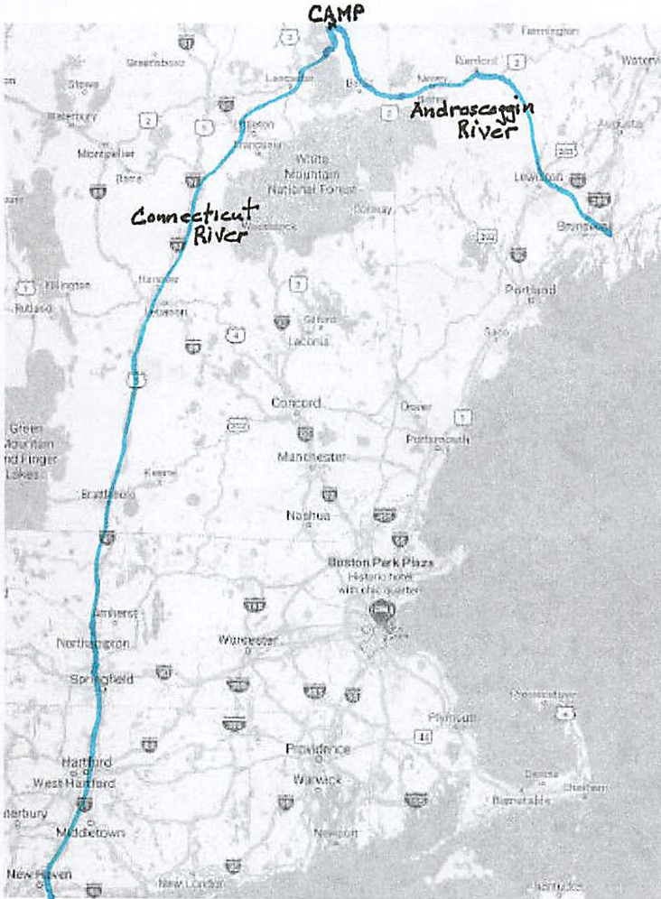
INTERESTING THOUGHT THAT JUST CAME TO ME YESTERDAY: The waters from the cedar swamp that go to Pontook flow down the Androscoggin through Maine. Those that flow into Cedar Brook empty into the Upper Ammonoosuc and then into the Connecticut River. So, waters from our property reach the Atlantic Ocean at points separated by a couple hundred miles.
To the Writing It Down Homepage
Leave a Comment: symbios@condortales.com