When I graduated from high school in 1957, my desire to spend as much time as possible in the High Sierra had not diminished one bit, and I still had big dreams of trips yet to take. But as often happens, the next year saw our backpacking and climbing group scattered to various colleges and jobs. We never got together, again.
I wasn’t entirely mountain-less in 1958. In late summer, I spent a few days with my parents and younger brother at Tuolumne Meadows in Yosemite National Park (scene of most of my mountain adventures in 1956 and 1957), where I did some solo hiking and easy climbing. One evening, I hiked up Lembert Dome, a smooth granite monolith with wide views of the Tuolumne Sierra. Another day, I hiked to Elizabeth Lake, finished the climb up Unicorn Peak that I had aborted in a snow storm a couple years earlier, and came back to the Meadows cross-country, down a precipitous canyon under the south wall of Unicorn.

Elizabeth Lake from Unicorn Peak
To cap off the mini-adventure, Dad and I hiked the John Muir Trail to Lower Cathedral Lake and back, me taking a side trip up and down Fairview Dome on the way. Fairview is a very airy climb, with a little steep scrambling at the end,. However, the famous Yosemite granite is such that, even though very steep, the friction between rock and boots means you can walk at a 45 degree angle or so with almost no threat of slipping. It’s an exhilarating experience.

Tuolumne Meadows

Lower Cathedral Lake
I got another little taste of the Sierra in 1959, when we made a family camping excursion to Florence Lake, just north of the north end of Kings Canyon National Park. Florence Lake is a reservoir, completed in 1926 as part of a hydroelectric project, supplying water and power to the California lowlands. The water levels can vary quite a bit, but the lake is in a high granite canyon, so doesn’t look too bad even when low. The road into it in those days (and probably still, today) was steep, narrow, twisty, and long, so it discouraged a lot of casual campers. We didn’t have a lot of time there, but I took one hike up onto one of the high ridges west of the lake. On another day, all “the guys” hired a boat and operator to take us the length of the lake (over two miles), then we walked back. When we got off the boat, we were less than ten miles away from the John Muir Trail, the closest I ever got to Evolution Basin in Kings Canyon National Park, a place that had fascinated me when I first read about it in Starr’s guidebook to the High Sierra. (I never got any closer.)

Florence Lake
My next shot at the high country came in 1962. I had been working at a wildlife refuge in Nevada, and Sally joined me for my final week. When we left for home, we went via Mono Lake, Lee Vining, Tuolumne Meadows, and Yosemite Valley. It was Sally’s first look at Tuolumne, and we had planned to hike a little. The heat and the altitude and Sally's pregnant state made that impossible , so we drove on to Yosemite Valley. It was oppressively hot, but (despite it being Labor Day weekend!) we parked our car in the shadow of El Capitan, walked across a meadow, and found a spot on the Merced River. With thousands of people crowding the valley floor, we lazed and enjoyed the frigid water for several hours with no human interruptions. In the relative coolness of evening, we headed for home.
In June 1965, Sally, Shawn and I joined my family for a week in Yosemite Valley. The Valley was lovely, the waterfalls were flowing at their maximum, and there were (relatively) few people. One day, we hiked to the base of Vernal Falls, but that was the extent of our Sierra adventures off the Valley floor.
Perhaps it was the next year that Sally and I planned an early summer backpack trip into the Desolation area west of Lake Tahoe – an area I hadn’t visited since 1957. It had been a long winter, and we arrived at Echo Lake to find the entire Tahoe Sierra locked in a mantle of still-deep snow. It was nice to see mountains in the distance, but we barely got out of the car before heading home. Reestablishing my relationship with the High Country was not going well.
*****
Finally! In 1967 – ten years after the previous one -I actually made a backpacking trip in the High Sierra. It wasn’t a long one, but it really felt like Coming Home. Sally and I left the Bay Area before the sun came up, drove to Tuolumne Meadows, donned our packs, and hiked the three miles to Budd Lake. In those days, there was no official trail to the lake, but it was relatively easy to follow the routes made by previous hikers and fishermen. Budd Lake had been the “base camp” for some of my high school climbing adventures, so I remembered the way.
Not too many years after this trip, the National Park Service closed the Budd Lake area to overnight camping. It is just too accessible for the hordes of people visiting the Meadows, and the area was suffering the scars of overuse. From the perspective of 1967, that’s hard to imagine. I’m sure we didn’t see another soul after we left the immediate environs of the Meadows, nor did we see anybody else on our climbing trips there in the 1950s.
When we arrived at the lake, Sally was suffering a little bit – nausea, headache, tiredness. I wasn’t, but I had had my own personal experiences with “mountain sickness” in the past, the result of a rapid rise from sea level to 10,000 feet, with no time for the system to adjust to changes in air pressure and oxygen levels. A quiet hour or so in front of a fantastic mountain lake took care of the malady.
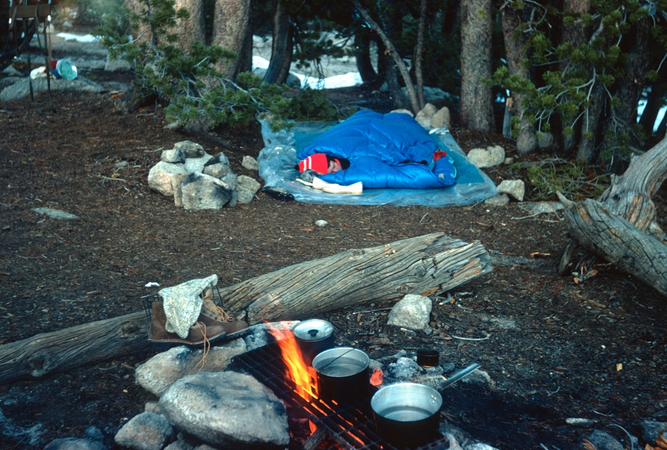
The lake was still snow covered and partially frozen, and there were snowbanks around us, but there was plenty of bare ground for our fire and our two-person down-filled sleeping bag. The night was clear and chilly, but no match for our superior accommodations.
The next morning, we hiked cross country between the Echo Peaks and Cathedral Peak, then down to meet the John Muir Trail near Lower Cathedral Lake. We followed the Muir Trail back to the Meadows, and drove home – a very satisfactory return to My Mountains.
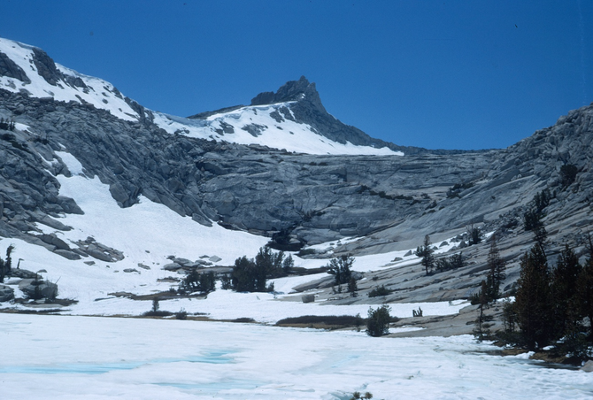
Budd Lake from our Camp
Sally not quite greeting the morning, yet

Hiking past the Echo Peaks
*****
In 1968, I had another chance at the mountains, this time with my dad from Wright’s Lake on the west side of Tahoe’s Pyramid Range. We had gone only a few miles up toward Pyramid Peak when Dad started having leg problems (a recurring issue for him). We found a scenic spot to camp for the night, then returned to the car and home the next day. We didn’t make the high country, but the wildflowers were great, as was the sunset.

Looking west from the Pyramid Range
*****
During the late 1960s and early 1970s, my work took me regularly to the western slopes of the Sierra Nevada. Occasionally, I got enticing views of the high country, but never got closer.
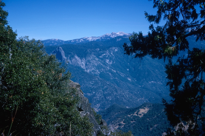
A glimpse of the High Country from Milk Ranch Fire Lookout, Sequoia National Park
Then, in 1975, I organized a two-day backpack trip for some of the men in our church. We started from Shake Camp in Sequoia National Forest, just south of the National Park, and wandered along the Tule River toward Hockett Meadows. I hadn’t been into that region, previously. It’s a gentler country than that farther north and east inside the Park, but with lots of open granite and green meadows, it was a quite satisfactory trip.


*****
The Tule River trip was followed by a long period of Sierra Deprivation for me. Then, in 1984, there were three brief encounters. While driving Sara home to Southern California, we took a detour to Yosemite Valley and took the hike to the top of Nevada Falls. The falls were lovely, and the trail traffic was (for Yosemite Valley) minimal. Three or four hours later, we were headed south, again.

Heading back to Oregon, Sally and I drove up the east side of the Sierra, stopping overnight at Mammoth Lakes and taking a short hike. Continuing north, we drove into Virginia Lake, north of Tioga Pass, just because I’d never been in there, before.

One of the Mammoth lakes

Virginia Lake
*****
My Sierra Nevada odyssey ended in September 1986, with a family trip to Tuolumne Meadows. We camped a couple nights in the Meadows, the first day hiking along the east side of the Meadows toward Mono Pass.

The next day, I wanted to show Budd Lake to Sara and Jeff. We started up the trail to where I “remembered” the turnoff to the lake but, after an hour or so of walking, it became clear I wasn’t where I thought I was. We were “lost,” but only in the sense that I didn’t know exactly where we were. Since either up or down would lead us to a trail back to Civilization, we continued on our way. The going was easy, the woods were lovely, and we had the world to ourselves. Eventually, we reached the shore of Elizabeth Lake – the other side of Unicorn Peak from Budd Lake – enjoyed the scenery for awhile, then took the Elizabeth Lake Trail back to the Meadows. Maybe not what I hoped for on my last visit to the High Sierra, but not a bad ending.

*****
In the quarter-century since I was last in the Sierra Nevada, I’ve been in my share of mountains. From the White Mountains of New Hampshire to the Cascades of the Pacific Northwest, and from British Columbia to Baja California, I’ve enjoyed my time in the high country. But did I really finish what I wanted to in California?
I never hiked the 200-mile John Muir Trail from end to end, an early dream of mine. However, I found that longer times at specific points along the trail were maybe more enjoyable than the marathon-like thru hike would have been.
I think I would have liked to hike up Mt. Whitney – just to say I’d done it – but it was never very high on my priority list. As I was composing this essay, only two of my early unfulfilled Sierra desires came to mind.
From my earliest climbing and backpacking days, I’d been fascinated with the Enchanted Gorge, in the Evolution region of northern Kings Canyon National Park. The name itself conjured up great images in my mind, but the overriding interest was that it was a cross-country route in what was the back-of-beyond beyond the Back of Beyond. Nobody went there.
I just now read the two accounts that had first piqued my interest. In 1895, Theodore Solomons described it as an idyllic jaunt through the wilderness.1 J. F. Hutchinson’s account of his 1923 traverse emphasized boulder-filled canyons and dangerous snow bridges at the beginning, and rattlesnakes and almost impenetrable brush at the end.2 I’d had my share of the latter two during my own cross-country pioneering in Kings Canyon, and the boulders and snow bridges just sounded like hard work to me. I guess the route is done regularly now – with mixed reviews. It would have been interesting to do, as it is still considered one of the most isolated regions in the High Sierra, but I think I can take it off my really-wish-I-had-done-that list.
The other regret has to stay, I think. It’s the area of Sequoia National Park including the Kings-Kern Divide and the Great Western Divide, a jumble of peaks, canyons, lakes and creeks with all kinds of exploration possibilities. It caught my attention first when I read William Brewer’s account of being in the area in the 1863, and making the first ascent of the mountain that now bears his name.3 I got a glimpse of the area, looking up East Creek Canyon from the Bubb’s Creek trail, in 1955 – my first view of the real High Country. From the top of Mt. Gardiner in 1956, I got the whole enticing display. I’m really sorry to have missed it all.

===============
1. Solomons, T. S. 1896. Mt. Goddard and vicinity — in the High Sierra of California. Appalachia 8:41-57.
2. Hutchinson, J. S. 1924. Goddard and Disappearing Creeks — the Enchanted Gorge. Sierra Club Bulletin 12(1):7-20.
3. Brewer, W. H. 2003. Up and Down California in 1860-1864.4th Edition. Berkeley, California: University of California Press.
To the Writing It Down Homepage
Leave a Comment: symbios@condortales.com